


National Trust ground-scanning technology maps new features close to site of Roman city of Wroxeter
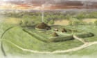
An archaeological survey of more than 1,000 hectares (2,471 acres) in Shropshire has identified a wealth of previously unknown features, including two grand Roman villas and multiple earlier iron age farmsteads.
The geophysical survey, the largest ever conducted by the National Trust, used ground-scanning technology to map undetected features close to the site of the Roman city of Wroxeter, just south of modern day Shrewsbury.
More Stories
Virologist Wendy Barclay: ‘Wild avian viruses are mixing up their genetics all the time. It’s like viral sex on steroids’
Microsoft unveils chip it says could bring quantum computing within years
‘It would be seen as political’: why the Royal Society is torn over Elon Musk