


A broad trough has dragged in warm, moist air and offers perfect ingredients for heavy rainfall and even supercells
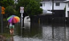
Northern parts of Australia have been under a flood warning this weekend, with further flooding set to bring havoc to south-eastern parts of the Northern Territory and western Queensland early this week. A broad trough – an area of locally lower pressure – has been moving across northern Australia, dragging in warm, moist air from the Gulf of Carpentaria and providing the perfect ingredients for the formation of severe thunderstorms, and even supercells.
More than 70mm (2.75in) of rain fell in an hour under the slow-moving storms over the weekend in what is usually an arid, low rainfall zone with a desert/grassland climate classification. Some parts of the region have sparse observation data, but some local stations have been able to record more than 100mm within 24 hours, with 132mm of rain at Marion Downs, Queensland.
More Stories
Campaigners mount coordinated protests across Europe against ‘touristification’
Australian deported from US says he was ‘targeted’ due to writing on pro-Palestine student protests
‘Keep calm and enjoy’: Italian village enlists ‘street tutors’ to ease overtourism