


Met Service issues red warning amid deepening low pressure as Europe sees above average temperatures
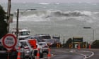
Strong winds and flooding spread across New Zealand last week, with a state of emergency declared in Christchurch, as the country was battered by a destructive area of low pressure this week. A red warning, the highest warning level, was issued by the MetService (the national meteorological service). The area of low pressure quickly deepened in the Tasman Sea off the west coast of New Zealand and then travelled eastwards across the country, with the centre of the low pressure moving across the northern island and creating very strong winds, particularly through the Cook Strait, the body of water that separates the two islands. This was because the wind direction was a south-easterly to southerly which caused the winds to strengthen as they were funnelled between the island.
The capital of New Zealand, Wellington, recorded some of the strongest winds, with gusts exceeding 90mph. Flooding was also an issue, especially for the southern island as the winds brought in moist air from the sea, which rapidly rose over the Southern Alps mountain range producing heavy rain. More than 100mm of rain fell in under 12 hours across some eastern areas and the local government called a state of emergency in Christchurch, the largest city in the southern island, as rivers burst their banks and roads closed. Across mountainous areas snow warnings were also issued, with some parts seeing over 50cm of snow in just 24 hours. Large swell was produced by the area of low pressure, with waves of almost 6 metres through the Cook strait.
More Stories
Hong Kong police tell people not to download ‘secessionist’ mobile game
Israel’s Iran threat is familiar, but it is unlikely to attack without US backing
Graz gunman was first-person shooter games obsessive, police say